See our project:
EDDY
Identification, tracking and classification of ocean eddies in along-track radar altimetry data using deep learning

©Ribana Roscher
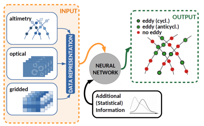
At mesoscale, eddies are observed in radar altimetry, and methods have been developed to identify, track and classify them in gridded maps of sea surface heights (SSH) derived from multi-mission datasets. However, this procedure has drawbacks since much information is lost in the gridding process. Here, we suggest to develop a method that would identify, track, and classify eddies predominantly from along-track altimetry.
We aim to develop a machine-learning approach, which utilize (1) multi-modal data (along-track altimetry data, MODIS data, SST), (2) reference data in the form of in-situ observations such as eddies detected in mooring data, novel SWOT SAR SSH data and (3) visual interpretation of satellite images (including SST). These multi-modal datasets will provide improved results (when compared to techniques applied to gridded data) in terms of eddy identification, classification, and tracking, in particular when applied to multi-mission along-track radar altimetry data.
Besides the real satellite observations, high-resolution, eddy-permitting ocean simulation datasets (FESOM) will also be used for preparing reference data and training. In the development of machine learning approach, we pass over from single-modal simulated SSH along-track data to multi-modal data such as simulated SST + SSH data. Thus, we will use a larger and a more comprehensive reference dataset with more detailed labels, which allows us to learn a model leading to more accurate results. The project focuses on three regions, namely the North Atlantic (mainly the Gulf Stream), Agulhas current region, and Mediterranean region.
EDDY project is an ongoing joint effort by scientists from two research groups at the University of Bonn and funded by DFG.
For more information see: https://gepris.dfg.de/gepris/projekt/444762031
